Save this image free of charge
in 800 pixels for layout use
(right click, Save as...)
|
|
Ref : T01296
Theme :
Looking at Earth - Cities (375 images)
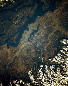
Title : Seattle and Puget Sound, Washington, U.S.A. March 1990
Caption :
Puget Sound and the Seattle area, flanked to the east by the snow-covered Cascade Range, are presented in this northeast-looking, low-oblique photograph. Built on seven hills between Puget Sound’s Elliot Bay and dark blue Lake Washington, Seattle lies in an earthquake-prone area. The city, the largest in the Pacific Northwest, is the region’s commercial, cultural, and transportation hub. It is a center for aircraft manufacturing and shipbuilding; other industries include food processing, electronics, computer software, lumber, chemicals, metal goods, machinery, textiles and apparel, and tourism. A major port of entry with excellent natural harbors, Seattle is important to Alaskan and Far Eastern trade. Small, turquoise Lake Sammamish lies east of Lake Washington. Interstate Highway 5 traverses from the north (through Everett, near the upper left) to the south (through Tacoma, midway between the bottom right and bottom center). Interstate Highway 90 crosses central Seattle and Lake Washington to the east and progresses south of Lake Sammamish into the snow-covered Cascades. Puget Sound, an arm of the Pacific Ocean connected with the Pacific by the Strait of Juan de Fuca, lies west of Seattle. The sound is more than 100 miles (160 kilometers) long, has numerous islands, and can be navigated by large ships.
|
|

